Image
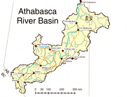
Map of Athabasca River Basin
Image
| Content type |
Content type
|
|---|---|
| Collection(s) |
Collection(s)
|
| Resource Type |
Resource Type
|
| Genre |
Genre
|
| Origin Information |
|
|---|
| Persons |
Creator (cre): Fiona Gregory
Contributor (ctb): Science Outreach - Athabasca
|
|---|
| Description / Synopsis |
Description / Synopsis
Map - The Athabasca River Basin in yellow; river and lakes in blue; outline of Province of Alberta |
|---|
| Publication Title |
Publication Title
|
|---|
| Physical Form |
Physical Form
|
|---|
| Local Identifier |
Local Identifier
arbriimge00004
|
|---|
| Note |
|
|---|
| Use and Reproduction |
Use and Reproduction
Copyright Fiona Gregory
|
|---|---|
| Rights Statement |
Rights Statement
|
| Use License |
| Subject Topic |
Subject Topic
|
|---|
Cite this
| Language |
English
|
|---|---|
| Name |
Map of Athabasca River Basin
|
| Authored on |
|
| MIME type |
image/jp2
|
| File size |
4949808
|
| Width |
5600px
|
| Height |
4280px
|
| Media Use |