Image
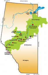
Map of Athabasca River Basin
Image
| Content type |
Content type
|
|---|---|
| Collection(s) |
Collection(s)
|
| Resource Type |
Resource Type
|
| Genre |
Genre
|
| Origin Information |
|
|---|
| Persons |
Creator (cre): Dennis Jacobs
Contributor (ctb): Science Outreach - Athabasca
|
|---|
| Description / Synopsis |
Description / Synopsis
Map - The Athabasca River Basin in green; lakes and rivers in blue; tan shaded Province of Alberta; names of surrounding provinces, etc.; transparent background |
|---|
| Publication Title |
Publication Title
|
|---|
| Physical Form |
Physical Form
|
|---|
| Local Identifier |
Local Identifier
arbriimge00026
|
|---|---|
| Handle |
Handle
Handle placeholder
|
| Note |
|
|---|
| Use and Reproduction |
Use and Reproduction
Copyright Science Outreach - Athabasca
|
|---|---|
| Use License |
| Subject Topic |
|---|
au_1483.jp2577.02 KB
Cite this
| Language |
English
|
|---|---|
| Name |
Map of Athabasca River Basin
|
| Authored on |
|
| MIME type |
image/jp2
|
| File size |
590869
|
| Width |
1695px
|
| Height |
2626px
|
| Media Use |