Image
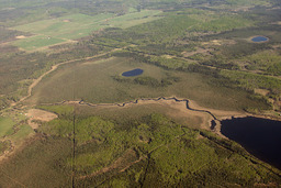
Aerial View of Land near Whitecourt, AB
Image
| Content type |
Content type
|
|---|---|
| Collection(s) |
Collection(s)
|
| Resource Type |
Resource Type
|
| Genre |
Genre
|
| Origin Information |
|
|---|
| Persons |
Creator (cre), Contributor (ctb): R.G. Holmberg
|
|---|
| Description / Synopsis |
Description / Synopsis
Photograph - Boreal forest, seismic cut lines, road, creek, part of lake, 2 ponds, some agriculture near Whitecourt, AB |
|---|
| Publication Title |
Publication Title
|
|---|
| Physical Form |
Physical Form
|
|---|
| Local Identifier |
Local Identifier
arbriimge00268
|
|---|
| Note |
|
|---|
| Use and Reproduction |
Use and Reproduction
Copyright R.G. Holmberg
Copyright R.G. Holmberg
|
|---|---|
| Rights Statement |
Rights Statement
|
| Use License |
| Subject Topic |
Subject Topic
|
|---|
au_1631.jp2704.04 KB
8094-Thumbnail Image.jpg22.69 KB
Cite this
| Language |
English
|
|---|---|
| Name |
Aerial View of Land near Whitecourt, AB
|
| Authored on |
|
| MIME type |
image/jp2
|
| File size |
720936
|
| Width |
1800px
|
| Height |
1200px
|
| Media Use |